Twelve Durham areas from Trinity Park to Woodcroft and Treyburn: ZIP codes, zoned high schools and August 2026 home values, from official data.
Last checked Oct. 12, 2026. Sources: the City of Durham’s GIS data (city limits, historic districts, neighborhood protection overlays and the Place Type Map) and Durham Comprehensive Plan, Durham Public Schools’ 2026-27 attendance zones, the N.C. Department of Public Instruction’s 2025-26 accountability data, the U.S. Census Bureau, OpenStreetMap and Zillow Research.
Durham covers about 125 square miles inside its city limits, in the city’s boundary data, and had 291,467 residents in the Census Bureau’s 2020-2024 American Community Survey (QuickFacts). Almost all of the city is in Durham County. The city’s comprehensive plan calls downtown “the historical center of economic activity in the city and county.”
Four things shape where people live:
- The main roads. The Durham Freeway (N.C. 147) runs past downtown from Interstate 85 in the northwest to Interstate 40 and Research Triangle Park in the southeast. I-85 crosses north Durham, I-40 crosses the south and U.S. 15-501 runs southwest toward Chapel Hill. Exit numbers on these pages are NCDOT’s.
- ZIP codes. The main residential ZIP codes are 27701 (downtown and the center), 27703 (east), 27704 (northeast), 27705 (northwest and the Duke area), 27707 (southwest), 27712 (north) and 27713 (south). A Durham address does not prove a home is inside the city: Treyburn, for example, is only partly in the city limits. Check a parcel on the county’s tax bill search.
- School zones do not follow city limits. Durham Public Schools serves the whole county, inside and outside the city, and assigns each address a base school. Many central neighborhoods, including downtown, Trinity Park and Old West Durham, are zoned for Riverside High, whose campus is in north Durham. A few small pieces of the city in Wake County, about 0.4 square mile in all, are outside the district’s zones.
- Historic districts. Durham has eight local historic districts, where state law requires a certificate of appropriateness before most exterior changes, and 24 National Register district listings, in the city’s historic district data. Several of the areas below are defined by them.
The areas at a glance
Zoned high school is the one most of the area is zoned for in Durham Public Schools’ 2026-27 attendance zones; check every address in the city’s school locator. Home value is the Zillow Home Value Index for the area’s main ZIP code in August 2026, a modeled typical value, not a sale price.
| Area | Main ZIP | Zoned high school | ZIP home value, Aug. 2026 | Guide |
|---|---|---|---|---|
| Downtown | 27701 | Riverside High | $421,664 | Downtown |
| Trinity Park | 27701 | Riverside High | $421,664 | Trinity Park |
| Duke Park | 27701 | Riverside High | $421,664 | Duke Park |
| Old West Durham | 27705 | Riverside High | $467,307 | Old West Durham |
| Watts-Hillandale | 27705 | Riverside High | $467,307 | Watts-Hillandale |
| Walltown | 27705 | Riverside High | $467,307 | Walltown |
| East Durham | 27703 | Riverside High | $379,924 | East Durham |
| Hayti | 27701 | Split: Jordan, Riverside, Hillside | $421,664 | Hayti |
| Forest Hills | 27707 | C.E. Jordan High | $406,475 | Forest Hills |
| Hope Valley | 27707 | C.E. Jordan High | $406,475 | Hope Valley |
| Woodcroft | 27713 | C.E. Jordan High | $415,724 | Woodcroft |
| Treyburn | 27712 | Northern High | $419,987 | Treyburn |
For the whole city, Zillow’s figure was $389,634 in August 2026, down 3.4% from August 2025. In 2025-26, 53.2% of Durham Public Schools’ state tests were at grade level or above, according to the state’s accountability data. More on prices in our home prices guide and on schools in our schools guide.
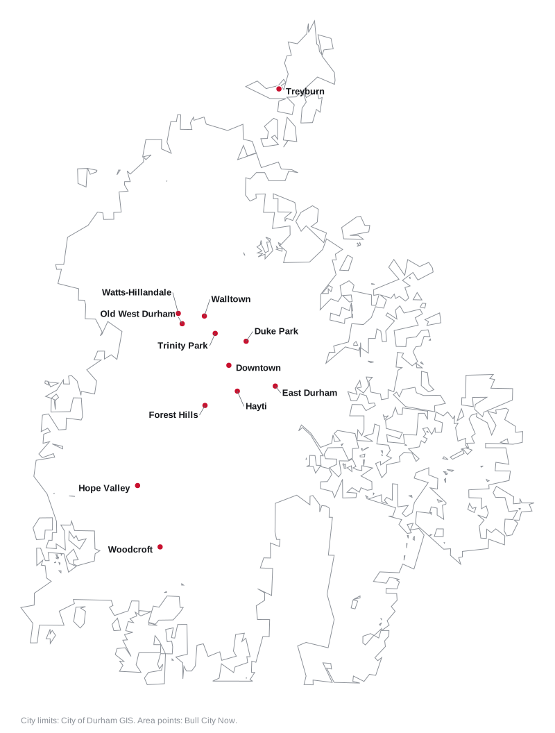
Map
Downtown
The city’s historic commercial center, about 0.9 square mile, with apartments and condominiums among offices, restaurants and Durham Central Park. A local and National Register historic district. Zoned for Riverside High; ZIP code 27701. Read the Downtown guide.
Trinity Park
The early 20th century neighborhood between Duke’s East Campus and downtown, listed on the National Register as the Trinity Historic District. Zoned for Riverside High, mostly George Watts Elementary. Read the Trinity Park guide.
Duke Park
The North Durham-Duke Park National Register district along North Mangum Street, including Old North Durham, next to the 18-acre city park. Zoned for Riverside High; ZIP code 27701. Read the Duke Park guide.
Old West Durham
The neighborhood around the Ninth Street shops, with its own city zoning overlay adopted in 2018. Zoned for E.K. Powe Elementary and Riverside High; ZIP code 27705. Read the Old West Durham guide.
Watts-Hillandale
A local and National Register historic district along Club Boulevard, north of Ninth Street. Zoned for E.K. Powe Elementary and Riverside High; ZIP code 27705. Read the Watts-Hillandale guide.
Walltown
The neighborhood around Walltown Park, north of Duke’s East Campus, named in the comprehensive plan’s transportation policy. Zoned for Riverside High; ZIP codes 27705 and 27701. Read the Walltown guide.
East Durham
A National Register district of homes, shops and former industrial buildings about a mile east of downtown, also named in the comprehensive plan. Zoned for Riverside High; mostly ZIP code 27703. Read the East Durham guide.
Hayti
The historic neighborhood just south of downtown that the comprehensive plan says was cut through by the Durham Freeway. Its school zones split three ways for high school. ZIP codes 27701 and 27707. Read the Hayti guide.
Forest Hills
A National Register district southwest of downtown around 45.9-acre Forest Hills Park. Zoned for C.E. Jordan High; ZIP code 27707. Read the Forest Hills guide.
Hope Valley
A 1920s suburb around Hope Valley Country Club, listed on the National Register in 2009. Zoned for C.E. Jordan High; ZIP code 27707. Read the Hope Valley guide.
Woodcroft
The planned area along Woodcroft Parkway in south Durham, near Southpoint, with the Third Fork Creek Greenway and the American Tobacco Trail. Mostly zoned for C.E. Jordan High; ZIP code 27713. Read the Woodcroft guide.
Treyburn
A planned area in north Durham County, only partly inside the city limits. Zoned for Northern High; mostly ZIP code 27712. Read the Treyburn guide.
Comparing towns
To compare Durham with Chapel Hill, Morrisville and Carrboro on taxes, schools, home values and commutes, see Durham vs Chapel Hill vs Morrisville vs Carrboro. Property tax details are in our property tax guide, parks in our parks and trails guide and roads and buses in our getting around guide. New to the city? See moving here.
How we built this
We named an area only when a public source names it as a place:
- The city’s planning data. The city’s GIS lists eight local historic districts, 24 National Register district listings and two neighborhood protection overlays. Downtown, Trinity Park, Watts-Hillandale, Duke Park, East Durham, Forest Hills and Hope Valley are drawn from those districts, and Old West Durham from its overlay.
- The comprehensive plan. The 2023 Durham Comprehensive Plan names Downtown, Hayti, Walltown and East Durham, and its Place Type Map describes the character of each area.
- OpenStreetMap. OpenStreetMap names Trinity Park, Old West Durham, Watts Hospital-Hillandale, Walltown, Duke Park, Old North Durham, Forest Hills, Hayti, Woodcroft and Treyburn as places, and draws boundaries for Downtown Durham and Treyburn. Walltown, Hayti and Woodcroft have no official boundary, so their pages use a circle around the OpenStreetMap point and say so.
School zones come from Durham Public Schools’ 2026-27 attendance zones, checked at points spread across each area, and test scores from the state’s 2025-26 accountability data. ZIP codes come from the Census Bureau’s ZIP code tabulation areas. Distances were measured on OpenStreetMap roads with the OSRM routing engine.
This guide does not yet cover Morehead Hill, Golden Belt, Lakewood, Burch Avenue or the Cleveland and Holloway street districts, which are also in the city’s historic district data, or Bragtown, which the comprehensive plan names. We found no city or county registry of homeowners associations, so the area guides describe them only where the plan does.
Frequently asked questions
What are the neighborhoods in Durham, NC?
This guide covers 12 areas named in the city’s planning data, its comprehensive plan or OpenStreetMap: Downtown, Trinity Park, Old West Durham, Watts-Hillandale, Walltown, Duke Park, East Durham, Hayti, Forest Hills, Hope Valley, Woodcroft and Treyburn.
What ZIP codes are in Durham?
Durham’s main ZIP codes are 27701, 27703, 27704, 27705, 27707, 27712 and 27713, with 27708 for Duke’s campus. A Durham mailing address does not always mean a home is inside the city limits.
Do Durham school zones follow city limits?
No. Durham Public Schools serves the whole county, inside and outside the city, and assigns schools by address. Many central neighborhoods are zoned for Riverside High in north Durham.
Which Durham ZIP code has the highest home values?
In August 2026 Zillow’s Home Value Index was $467,307 in 27705, $421,664 in 27701, $419,987 in 27712, $415,724 in 27713, $406,475 in 27707, $379,924 in 27703 and $305,949 in 27704. The city figure was $389,634.
Have your say